Barker Pass is located in the Lake Tahoe area, and it is a very reliable location for wildflowers. You can find wildflowers right along the road, but I recommend hiking in on the Tahoe Rim trail for the greatest variety. An added benefit is that it takes you away from the large crowds that clog the more popular areas closer to Lake Tahoe. This hike includes exposed volcanic bluffs, shaded forest, and several wonderful mountain seeps/meadows.
The Hike
The soils here are primarily volcanic origin, gray sand and slate with an occasional lava plug. It can be pretty dry in most places, although there are several interesting seeps that are full of flowers. The trail alternates between gray sand, slate rockfalls, fir forest, and mountain streams/seeps, so you can find a variety of flowers that changes throughout the season.
On this hike our goal was a larger hillside meadow that is about 3.2 miles in from the trailhead. The starting elevation is about 7670′ and you climb up to 8280′, then you drop down a bit to several hillside meadows/seeps.
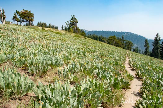
Initially the trail is very dry, primarily exposed gray volcanic sand. This hike was in early August of a dry year, and on the first section of the trail most of the flowers had already gone to seed. There were a lot of paintbrush and stickseed, with many other flowers, but not many blooms remained. We were worried that we were hiking too late in the season. I’ll note that last year, which had a lot more rain, we hiked in this general area and everything was much greener.
About a mile in you come to some hillsides covered with mules ear and balsam root, but these were all finished blooming, too.
Pushing on, the trail is almost all uphill, but with a gentle slope. The trail is a part of the Tahoe Rim Trail and Pacific Crest Trail, and it is very well maintained. At 1.5 miles there is a split in the trail. If you go right, in a few hundred feet you come to a spot that looks out towards Lake Tahoe. It’s a great view if there isn’t a lot of smoke from wildfires, as there was this day. Heading back to the trail junction, take the main/middle branch.
After this you spend more time in the trees, and the shade is welcome. At 2 miles there is a stream crossing the trail, with a nice collection of flowers, very different than the hot dry portion up to here. Several species of monkeyflower, some lilies, bog orchids, and more.
Continuing on, the trail alternates between forest and open exposed areas. You will cross several rockfalls of slate that sound like you are walking on broken crockery.
 At 2.8 miles you have reached the lava plug. The trail splits, you can go right to see the plug but the main trail continues to the left. The exposed slope leading up to this point has Lobb’s buckwheat, which looks almost like a robust version of pussy paws. From the lava plug the trails goes downhill. Tired hikers may think about turning around here, but it isn’t too steep to continue, and you are close to the best of the hillside gardens.
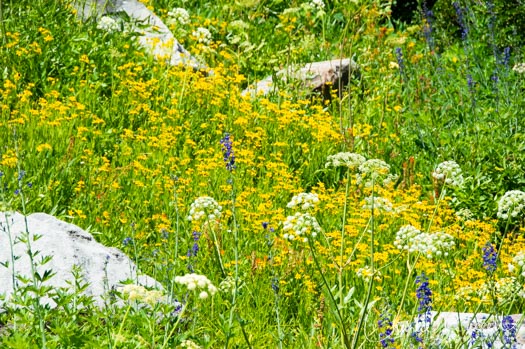
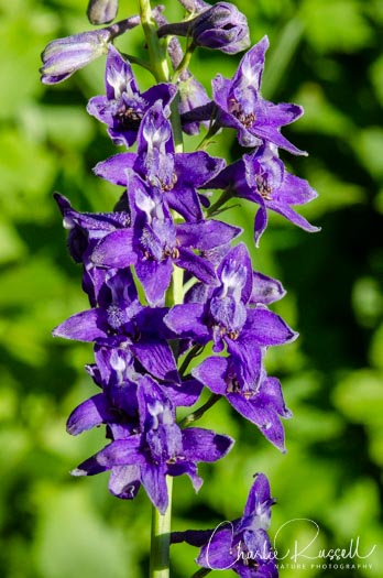
At 3.2 miles there is a nice seep/hillside meadow that has many flowers, but you want to continue on. At 3.5 miles is a much larger seep/hillside meadow that is full of larkspur and arnica, masses of Gray’s lovage, and many more flowers. Hummingbirds were buzzing all around. We were able to find a nice patch of Explorer’s gentian blooming on the downhill side, just off the trail. It was a wonderful collection of flowers!
This is where we turned around. I’m not sure what you might find beyond this point, but I think that this is the last seep for a ways.
Here are some photos of the trail. Click on any image to see a larger version.


Here’s the track that we followed:
Barker Pass
Profile
Move your mouse along the elevation graph to show the location on the map. The Refresh icon will re-center the map. The Expand icon will expand to full screen.
Directions
Barker Pass is on the west side of Lake Tahoe. Starting at Tahoe City on Highway 89, go south on 89 for 4.2 miles. Barker Pass Road goes west from 89, it might be hard to see because the street sign is back off the highway a ways. This is the Kaspian Recreation Area, and it is the next road after Elizabeth Drive.
At 2.3 miles there is a split in the road, take the left branch (it looks like the main option). Continue another 5.1 miles after this, to the trailhead.
Near the end you will see a parking area on your left, and probably a lot of cars. This is the Ellis Peak trailhead, which apparently gets a lot more traffic. Continue past this – the paved road becomes a broad gravel/dirt road. Shortly after this you will see a large Barker Pass trailhead sign on your right. Park here (lots of room). There is a pit toilet here, and a picnic bench.
If you aren’t looking for a long hike, there are several roadside seeps along the drive up. Some years there are a lot of flowers here. You can also drive past the trailhead and find some additional hillside seeps, but note that the road gets rougher past this point. The seeps are better in wetter years.
Timing is Everything
This visit was in the first week of August on a low rainfall year. Temperatures were in the low 80’s, but there is a fair amount of shade once you get past the first, exposed portion of the trail. The seeps were in full bloom and wonderful, the exposed areas were dry and everything had gone to seed. This would be a great hike for masses of mules ears, arrowroot, scarlet gilia, and paintbrush, earlier in the year. Early July, perhaps? I think that the seeps would not be in full bloom then, though. You also could do this hike later in August, later season flowers like the Gentians were just starting to open up on this trip.
The Flowers
Here’s a sample of a few of my favorites from this hike.
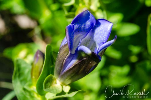
The star of this hike was the Explorer’s gentian, which was just starting to bloom at the larger seep at the end of the hike. Easy to miss this time, another hiker who passed this way a few days later said he didn’t find them. I love the deep blue color of these flowers.
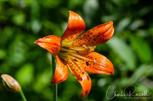
At the first stream/seep we found a solitary Alpine lily, up the hill a ways.
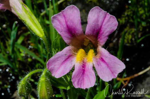
At several of the seeps we found Lewis’ monkey flower.
The larger seep had huge spikes of Mountain larkspur, very popular with the hummingbirds.
For the best viewing experience, click on the lightbox image below, and you can scroll through larger versions of the photos of many of the plants (and other things) that we found on this hike. All photos are available for purchase in a variety of formats.


Barker Pass Wildflowers
Here’s a listing of the native plants that we found on this visit. The ones listed in color are endemic to California (that is, found only in California).
- Alpine lily, Lilium parvum
- Anderson’s thistle, Cirsium andersonii
- Arrowleaf ragwort, Senecio triangularis
- Bog wintergreen, Pyrola asarifolia
- Brewer’s angelica, Angelica breweri
- Brewer’s aster, Eucephalus breweri
- Brewer’s lupine, Lupinus breweri var. breweri
- Brook saxifrage, Micranthes odontoloma
- Common yarrow, Achillea millefolium
- Corn lily, Veratrum californicum
- Coulter’s daisy, Erigeron coulteri
- Cow parsnip, Heracleum maximum
- Coyote mint, Monardella odoratissima
- Crimson columbine, Aquilegia formosa
- Cusick’s speedwell, Veronica cusickii, CNPS Rare Plant Rank: 4.3
- Explorer’s gentian, Gentiana calycosa
- Fendler’s meadow rue, Thalictrum fendleri
- Fireweed, Chamerion angustifolium
- Fringed willowherb, Epilobium ciliatum ssp. ciliatum
- Glaucous willow herb, Epilobium glaberrimum
- Gray’s lovage, Ligusticum grayi
- Hairy arnica, Arnica mollis
- Larger mountain monkeyflower, Erythranthe tilingii
- Lewis’ monkey flower, Erythranthe lewisii
- Little elephant’s head, Pedicularis attollens
- Mountain blue penstemon, Penstemon laetus
- Mountain larkspur, Delphinium glaucum
- Musk monkeyflower, Erythranthe inodora
- Naked buckwheat, Eriogonum nudum
- Pearly everlasting, Anaphalis margaritacea
- Pine drops, Pterospora andromedea
- Pink alumroot, Heuchera rubescens
- Rose meadowsweet, Spiraea splendens
- Scarlet gilia, Ipomopsis aggregata
- Scarlet paintbrush, Castilleja miniata
- Slender cinquefoil, Potentilla gracilis
- Sierra primrose, Primula suffrutescens
- Sparse flowered bog orchid, Platanthera sparsiflora
- Spreading groundsmoke, Gayophytum diffusum ssp. parviflorum
- Tinker’s penny, Hypericum anagalloides
- Wavy leaf paintbrush, Castilleja applegatei
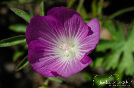
- Waxy checkerbloom, Sidalcea glaucescens
- Western mountain aster, Symphyotrichum spathulatum
- White veined wintergreen, Pyrola picta
